

Heath dominated by one or more of Regelia megacephala, Kunzea ...
Heath dominated by one or more of Regelia megacephala, Kunzea ...
Heath dominated by one or more of Regelia megacephala, Kunzea ...

You also want an ePaper? Increase the reach of your titles
YUMPU automatically turns print PDFs into web optimized ePapers that Google loves.
INTERIM RECOVERY PLAN NO. 65<br />
<strong>Heath</strong> <strong>dominated</strong> <strong>by</strong> <strong>one</strong> <strong>or</strong> m<strong>or</strong>e <strong>of</strong><br />
<strong>Regelia</strong> <strong>megacephala</strong>, <strong>Kunzea</strong> praestans and<br />
Allocasuarina campestris on ridges and slopes <strong>of</strong> the<br />
chert hills <strong>of</strong> the Coomberdale Fl<strong>or</strong>istic Region<br />
Interim Recovery Plan<br />
2000-2003<br />
<strong>by</strong><br />
Sheila Hamilton-Brown<br />
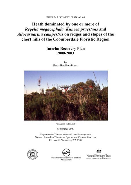
Photograph: Val English<br />
September 2000<br />
Department <strong>of</strong> Conservation and Land Management<br />
Western Australian Threatened Species and Communities Unit<br />
PO Box 51, Wanneroo, WA 6946<br />
Department <strong>of</strong> Conservation and Land<br />
Management
FOREWORD<br />
Interim Recovery Plan No. 65<br />
Interim Recovery Plans (IRPs) are developed within the framew<strong>or</strong>k laid down in Department <strong>of</strong><br />
Conservation and Land Management (CALM) Policy Statements Nos 44 and 50<br />
IRPs outline the recovery actions that are required to urgently address those threatening processes most<br />
affecting the ongoing survival <strong>of</strong> threatened taxa <strong>or</strong> ecological communities, and begin the recovery<br />
process.<br />
CALM is committed to ensuring that Critically Endangered, and where appropriate and feasible, other<br />
threatened ecological communities are conserved through the preparation and implementation <strong>of</strong><br />
Recovery Plans <strong>or</strong> Interim Recovery Plans. CALM will also ensure that conservation action commences<br />
as soon as possible and always within three years <strong>of</strong> end<strong>or</strong>sement <strong>of</strong> Endangered rank <strong>by</strong> CALM's<br />
Direct<strong>or</strong> <strong>of</strong> Nature Conservation.<br />
This Interim Recovery Plan will operate from 11 September 2000 but will remain in f<strong>or</strong>ce until<br />
withdrawn <strong>or</strong> replaced.<br />
The provision <strong>of</strong> funds identified in this Interim Recovery Plan is dependent on budgetary and other<br />
constraints affecting CALM, as well as the need to address other pri<strong>or</strong>ities.<br />
Inf<strong>or</strong>mation in this IRP was accurate at 18 August 2000.<br />
2
SUMMARY<br />
Interim Recovery Plan No. 65<br />
Name: <strong>Heath</strong> <strong>dominated</strong> <strong>by</strong> <strong>one</strong> <strong>or</strong> m<strong>or</strong>e <strong>of</strong> <strong>Regelia</strong> <strong>megacephala</strong>, <strong>Kunzea</strong> praestans and<br />
Allocasuarina campestris on ridges and slopes <strong>of</strong> the chert hills <strong>of</strong> the Coomberdale<br />
Fl<strong>or</strong>istic Region.<br />
Description: This community consists <strong>of</strong> tall, dense heath <strong>dominated</strong> <strong>by</strong> either <strong>Regelia</strong> <strong>megacephala</strong> <strong>or</strong><br />
Allocasuarina campestris on exposed chert ridges; tall, dense heath <strong>or</strong> open low woodland over dense<br />
to mid-dense heath <strong>dominated</strong> <strong>by</strong> <strong>Kunzea</strong> praestans <strong>or</strong> Allocasuarina campestris on shallow loamy<br />
rocky soil over chert on the slopes and ridges <strong>of</strong> chert hills. The suite <strong>of</strong> plant species associated with<br />
the dominant species named above includes <strong>one</strong> <strong>or</strong> m<strong>or</strong>e <strong>of</strong> Dryandra fraseri var. fraseri, Dryandra<br />
sessilis, Hibbertia subvaginata, Xanth<strong>or</strong>rhoea drummondii, Melaleuca sp., Calothamnus quadrifidus<br />
and Calytrix leschenaultii.<br />
IBRA Bi<strong>or</strong>egion: Avon Wheatbelt<br />
CALM Region: Midwest Region<br />
CALM District: Mo<strong>or</strong>a<br />
Recovery Team: Mo<strong>or</strong>a Threatened Fl<strong>or</strong>a Recovery Team.<br />
Current status: This community was assessed <strong>by</strong> the Threatened Ecological Communities Scientific<br />
Advis<strong>or</strong>y Committee on the 29 October 1999 as Endangered; this status was end<strong>or</strong>sed <strong>by</strong> CALM's<br />
Direct<strong>or</strong> <strong>of</strong> Nature Conservation on 24 November 1999.<br />
Critical habitat: The area <strong>of</strong> occupancy <strong>of</strong> the known occurrences c<strong>or</strong>responding to the outcrop <strong>of</strong><br />
Noondine chert from Jingemia to Mo<strong>or</strong>a (Carter and Lipple 1982).<br />
IRP Objective(s): To improve the overall health <strong>of</strong> the community and reduce the level <strong>of</strong> threat so that<br />
the community does not move into the higher categ<strong>or</strong>y <strong>of</strong> Critically Endangered.<br />
Criteria f<strong>or</strong> success:<br />
1. Maintenance <strong>of</strong> the diversity and composition <strong>of</strong> the native species in the community.<br />
2. An increase in the area <strong>of</strong> this community under conservation management.<br />
3. Improvement in terms <strong>of</strong> reduction <strong>of</strong> threatening processes as defined in this document.<br />
Criteria f<strong>or</strong> failure:<br />
Significant loss <strong>of</strong> area <strong>or</strong> further modification <strong>of</strong> occurrences <strong>of</strong> the threatened ecological community.<br />
Summary <strong>of</strong> recovery actions f<strong>or</strong> the heath community on the chert hills <strong>of</strong> the Coomberdale<br />
Fl<strong>or</strong>istic Region.<br />
1. F<strong>or</strong>m and maintain a Recovery Team<br />
2. Clarify the extent <strong>of</strong> the community and locate m<strong>or</strong>e occurrences<br />
3. Monit<strong>or</strong> the extent and boundaries <strong>of</strong> the community<br />
4. Design and implement a program f<strong>or</strong> monit<strong>or</strong>ing the fl<strong>or</strong>a <strong>of</strong> the heath community<br />
5. Continue to liaise with current owners, land managers and other interested groups<br />
6. Encourage and assist landowners to access available incentives and mechanisms f<strong>or</strong> conserving the<br />
community<br />
7. Seek rate rebates f<strong>or</strong> landowners protecting occurrences<br />
8. Fence all known occurrences<br />
3
Interim Recovery Plan No. 65<br />
9. Design and implement weed control strategy<br />
10. Implement replanting and rehabilitation where necessary<br />
11. Determine the fire ecology <strong>of</strong> the community<br />
12. Design and apply appropriate fire management plans<br />
13. Liaise with surrounding landholders to ensure strategies f<strong>or</strong> fuel reduction on their lands do not<br />
impact on the community<br />
14. Seek to acquire occurrences on private land f<strong>or</strong> addition to the conservation reserve system<br />
1 BACKGROUND<br />
Hist<strong>or</strong>y, defining characteristics <strong>of</strong> ecological community, and conservation significance<br />
Noondine (= Coomberdale) chert is a discontinuous, narrow (up to 14 km wide) band <strong>of</strong> the Mo<strong>or</strong>a<br />
group <strong>of</strong> Proterozoic rocks stretching from Carnamah to Mo<strong>or</strong>a (Baxter and Lipple 1985, Carter and<br />
Lipple 1982). The Coomberdale Fl<strong>or</strong>istic Region c<strong>or</strong>responds to the discontinuous, narrow (~2-10 km<br />
wide) outcrop <strong>of</strong> Noondine chert from Jingemia to Mo<strong>or</strong>a with the largest most extensive outcrop<br />
between Coomberdale and Dalaroo (Carter and Lipple 1982, Griffin 1992).<br />
Three closely related vegetation sub-types occur on the exposed chert ridges and gravelly slopes <strong>of</strong> the<br />
chert hills in the Coomberdale Fl<strong>or</strong>istic Region that are recognisably different from other vegetation<br />
types within this fl<strong>or</strong>istic region and other fl<strong>or</strong>istic regions (Griffin 1992, 1994). These consist <strong>of</strong> dense<br />
heath <strong>dominated</strong> <strong>by</strong> <strong>Regelia</strong> <strong>megacephala</strong> <strong>or</strong> Allocasuarina campestris on the exposed chert ridges<br />
(sub-type 1); <strong>or</strong> dense heath <strong>or</strong> open low woodland over dense to mid-dense heath <strong>dominated</strong> <strong>by</strong><br />
<strong>Kunzea</strong> praestans (sub-type 2) <strong>or</strong> Allocasuarina campestris (sub-type 3) on shallow loamy rocky soil<br />
over chert on the slopes and ridges (Table 1). One <strong>or</strong> m<strong>or</strong>e <strong>of</strong> Dryandra fraseri var. fraseri, Dryandra<br />
sessilis, Hibbertia subvaginata, Xanth<strong>or</strong>rhoea drummondii, Melaleuca sp., Calothamnus quadrifidus<br />
and Calytrix leschenaultii are common to all sub-types.<br />
Table 1: Summary <strong>of</strong> the heath community sub-types on the chert hills <strong>of</strong> the<br />
Coomberdale Fl<strong>or</strong>istic Region.<br />
Sub-type Habitat Dominant species Occurrences*<br />
1 Exposed chert ridges <strong>Regelia</strong> <strong>megacephala</strong> 1-5<br />
2 Gravelly slopes <strong>Kunzea</strong> praestans 1-5<br />
3 Chert ridges and gravelly slopes Allocasuarina campestris 1-8<br />
*Refer Table 3<br />
The heath community also supp<strong>or</strong>ts six ‘Declared Rare’ <strong>or</strong> ‘Pri<strong>or</strong>ity’ taxa (including <strong>Regelia</strong><br />
<strong>megacephala</strong>) that are either totally <strong>or</strong> largely confined to these chert hills (Table 2).<br />
Table 2: List <strong>of</strong> Declared Rare (threatened) and Pri<strong>or</strong>ity Taxa (Dept. CALM 1999)<br />
Species Conservation categ<strong>or</strong>y<br />
Acacia aristulata R<br />
Baeckea sp. Mo<strong>or</strong>a P1<br />
Daviesia dielsii R<br />
Goodenia arthrotricha P1<br />
<strong>Regelia</strong> <strong>megacephala</strong> P4<br />
Synaphea quartzitica R<br />
4
Interim Recovery Plan No. 65<br />
The chert substrate is highly restricted and there are currently only 8 known occurrences <strong>of</strong> the heath<br />
community. The maj<strong>or</strong> threats to the community are weed invasion, grazing, inappropriate fire regimes,<br />
clearing and mining.<br />
Description <strong>of</strong> Occurrences<br />
All the known occurrences are located in the Shire <strong>of</strong> Mo<strong>or</strong>a on the range <strong>of</strong> Noondine chert hills that<br />
extend discontinuously from Jingemia south to Mo<strong>or</strong>a, ie. the Coomberdale Fl<strong>or</strong>istic Region. Table 3<br />
summarises the occurrence inf<strong>or</strong>mation.<br />
Table 3: Summary <strong>of</strong> occurrence inf<strong>or</strong>mation and threats<br />
Occ. Land Status Estimated<br />
area (ha)<br />
Condition Threats<br />
1 Private land including 152 Slightly to moderately Mining, grazing and weed<br />
"Cairn Hill"<br />
modified<br />
invasion<br />
2 Private land 17 Highly modified Fragmentation, grazing, fire and<br />
weed invasion<br />
3 Private land 25 Insignificantly to slightly<br />
modified<br />
Fire and weed invasion<br />
4 Private land 60 Highly to Completely<br />
modified<br />
Mining, fire and weed invasion<br />
5 Private land 272 Moderately modified Grazing, fire and weed invasion<br />
6 Water Reserve 10 Highly modified Recreational trampling, grazing<br />
(40089)<br />
and weed invasion<br />
7 National Park<br />
(Watheroo NP) and<br />
Private land<br />
100 Insignificantly modified Grazing, fire and weed invasion<br />
8 Private land 15 Slightly to moderately<br />
modified<br />
Grazing, fire and weed invasion<br />
Occurrence 1 is spread across 3 freehold properties 12 km n<strong>or</strong>th <strong>of</strong> Mo<strong>or</strong>a. The Threatened Ecological<br />
Community (TEC) comprises 152 ha <strong>of</strong> the 251 ha <strong>of</strong> remnant vegetation. The remaining vegetation<br />
comprises mixed low heath and vestiges <strong>of</strong> the once widespread Eucalyptus loxophleba woodland on<br />
the plains and valley flo<strong>or</strong>s (Griffin 1992). The n<strong>or</strong>thern p<strong>or</strong>tion <strong>of</strong> Occurrence 1 (61 ha) is on private<br />
land and is only known to have been inspected once to locate <strong>Regelia</strong> <strong>megacephala</strong> (Burgman 1983).<br />
The central p<strong>or</strong>tion <strong>of</strong> Occurrence 1 (79 ha, known as ‘Cairn Hill’) is owned freehold <strong>by</strong> Westrail and is<br />
apparently the most intact p<strong>or</strong>tion. The Mo<strong>or</strong>a Shire has, until recently, been extracting gravel from the<br />
base <strong>of</strong> this p<strong>or</strong>tion <strong>of</strong> the hills which has extended up into the edges <strong>of</strong> the heath community. Two<br />
radio and television towers are located on the highest p<strong>or</strong>tion <strong>of</strong> the hills in the centre <strong>of</strong> the Westrail<br />
land, and low land on the eastern p<strong>or</strong>tion <strong>of</strong> this land is currently under a grazing lease. There is a<br />
prospecting lease over much <strong>of</strong> the central and n<strong>or</strong>thern p<strong>or</strong>tions <strong>of</strong> Occurrence 1 f<strong>or</strong> the purposes <strong>of</strong><br />
extracting chert with expl<strong>or</strong>ation tracks over a segment <strong>of</strong> the n<strong>or</strong>thern p<strong>or</strong>tion.<br />
The southern and smallest p<strong>or</strong>tion (12 ha) <strong>of</strong> Occurrence 1 is located on private land that is heavily<br />
grazed with vegetation only on the summits. Occurrence 2 (17 ha) occurs on the same property and<br />
comprises m<strong>or</strong>e <strong>of</strong> the TEC fragmented into six p<strong>or</strong>tions, with the largest site 7 ha and the smallest 0.5<br />
ha.<br />
Occurrence 3 is located on private land 7 km n<strong>or</strong>th-east <strong>of</strong> Mo<strong>or</strong>a. The TEC comprises 25 ha <strong>of</strong> the 54<br />
ha <strong>of</strong> remnant vegetation surrounded <strong>by</strong> cropping land; the remainder <strong>of</strong> the remnant vegetation<br />
comprising Eucalyptus loxophleba and E. salmonophloia woodland in the lower areas. The occurrence<br />
has not been grazed f<strong>or</strong> at least seven years and has recently been fenced under the Remnant Vegetation<br />
Protection Scheme.<br />
5
Interim Recovery Plan No. 65<br />
Occurrence 4 is located on private land 0.25 km n<strong>or</strong>th <strong>of</strong> Occurrence 1. The TEC <strong>or</strong>iginally comprised<br />
60 ha <strong>of</strong> the 95 ha <strong>of</strong> remnant vegetation - surrounded <strong>by</strong> cropping land – but 45 ha was mined f<strong>or</strong><br />
chert. Expl<strong>or</strong>ation tracks traverse the rest <strong>of</strong> the occurrence and the remnant vegetation.<br />
Occurrence 5 is the largest occurrence and is located on private land 0.5 km n<strong>or</strong>th <strong>of</strong> occurrence 4. As<br />
with four previously menti<strong>one</strong>d occurrences, the three sub types are represented on this occurrence as<br />
well as an Acacia acuminata thicket on top <strong>of</strong> <strong>one</strong> ridge and a Eucalyptus loxophleba and E. wandoo<br />
woodland on the lower west side. The occurrence – spread across 3 freehold properties – is fragmented;<br />
with cropping and grazing lands between hills and on the lower slopes. Only 21 ha <strong>of</strong> the occurrence<br />
has been fenced f<strong>or</strong> conservation and covenanted under the Remnant Vegetation Protection Scheme. In<br />
1981 a fire swept through the south eastern side <strong>of</strong> the occurrence affecting the fenced p<strong>or</strong>tion and the<br />
hill <strong>dominated</strong> <strong>by</strong> Acacia acuminata.<br />
Of the total 668 ha <strong>of</strong> the community across all occurrences, 60 ha occur in two reserves. Occurrence 6<br />
(10 ha) is in a water reserve 1 km east <strong>of</strong> Mo<strong>or</strong>a - surrounded <strong>by</strong> agricultural land - managed <strong>by</strong> the<br />
Water C<strong>or</strong>p<strong>or</strong>ation. Only sub type 3 is represented in this reserve, although <strong>Regelia</strong> <strong>megacephala</strong> was<br />
thought to occur on the reserve (T. Griffin, personal communication 1 ). Much <strong>of</strong> the reserve has been<br />
cleared f<strong>or</strong> gravel extraction and access tracks, and has been trampled through recreational use.<br />
Occurrence 7 includes the only p<strong>or</strong>tion <strong>of</strong> the TEC (sub type 3 only) in conservation reserve - 50 ha in<br />
Watheroo National Park vested in the National Parks and Nature Conservation Auth<strong>or</strong>ity and managed<br />
<strong>by</strong> the Department <strong>of</strong> Conservation and Land Management (CALM). The remainder <strong>of</strong> the occurrence<br />
is on private land. The National Park p<strong>or</strong>tion part <strong>of</strong> it is on the edge <strong>of</strong> the park and b<strong>or</strong>ders a gravel<br />
road. The rest is surrounded <strong>by</strong> extensive, intact Eucalyptus loxophleba and mallee woodlands. The<br />
privately owned p<strong>or</strong>tions are surrounded <strong>by</strong> agricultural land and are currently grazed.<br />
Occurrence 8 is located on private land 2 km west <strong>of</strong> occurrence 4. The TEC comprises 15 ha <strong>of</strong> the 35<br />
ha <strong>of</strong> remnant vegetation and the remainder is Eucalyptus loxophleba, E. salmonophloia and E. wandoo<br />
woodland.<br />
Critical Habitat<br />
Critical habitat is habitat identified as being critical to the survival <strong>of</strong> a listed threatened species <strong>or</strong> listed<br />
threatened ecological community. Habitat is defined as the biophysical medium <strong>or</strong> media (a) occupied<br />
(continuously, periodically <strong>or</strong> occasionally) <strong>by</strong> an <strong>or</strong>ganism <strong>or</strong> group <strong>of</strong> <strong>or</strong>ganisms; <strong>or</strong> (b) once occupied<br />
(continuously, periodically <strong>or</strong> occasionally) <strong>by</strong> an <strong>or</strong>ganism, <strong>or</strong> group <strong>of</strong> <strong>or</strong>ganisms, and into which<br />
<strong>or</strong>ganisms <strong>of</strong> that kind that the potential to be reintroduced. (sections 207A and 528 <strong>of</strong> Commonwealth<br />
Environment Protection and Biodiversity Conservation Act 1999 (EPBC Act)).<br />
The critical habitat f<strong>or</strong> the heath community on the chert hills <strong>of</strong> the Coomberdale fl<strong>or</strong>istic region<br />
comprises the area <strong>of</strong> occupancy <strong>of</strong> the known occurrences c<strong>or</strong>responding to the outcrop <strong>of</strong> Noondine<br />
chert from Jingemia to Mo<strong>or</strong>a (Carter and Lipple 1982).<br />
Biological and ecological characteristics<br />
The fl<strong>or</strong>istic composition <strong>of</strong> the heath community is assumed to c<strong>or</strong>respond to the soil/substrate types<br />
and depths: <strong>Regelia</strong> <strong>megacephala</strong>, f<strong>or</strong> example, is only found where chert is exposed at the summit <strong>of</strong><br />
the hills. Otherwise, little is known <strong>of</strong> the biology and ecology <strong>of</strong> the community and gaining m<strong>or</strong>e<br />
inf<strong>or</strong>mation is a pri<strong>or</strong>ity in this Interim Recovery Plan.<br />
1 Ted Griffin – Research Officer, Agriculture WA, Perth<br />
6
Threatening processes<br />
Interim Recovery Plan No. 65<br />
Only eight occurrences are currently known. With the exception <strong>of</strong> the occurrence within the National<br />
Park (Occurrence 7), all the other occurrences are surrounded <strong>by</strong> agricultural land – many with very<br />
little <strong>or</strong> no native vegetation buffer (eg. Occurrence 2 is fragmented into six small areas with no<br />
vegetation on the lower slopes and the valleys). Of the three vegetation sub-types that make up the<br />
community, only sub-type 3 is in a conservation reserve (in the National Park). Potential and current<br />
threatening processes to individual occurrences were summarised in Table 3 and are elab<strong>or</strong>ated as<br />
follows:<br />
Clearing<br />
Clearing f<strong>or</strong> agriculture in the Shire <strong>of</strong> Mo<strong>or</strong>a has been extensive with some 85% <strong>of</strong> vegetation in the<br />
area cleared (B. Lullfitz, personal communication 2 ). New proposals to clear <strong>one</strong> ha <strong>or</strong> m<strong>or</strong>e <strong>of</strong> any<br />
occurrences, and/<strong>or</strong> <strong>of</strong> the surrounding vegetation, <strong>of</strong> this community on private land would be subject<br />
to assessment in acc<strong>or</strong>dance with the Mem<strong>or</strong>andum <strong>of</strong> Understanding f<strong>or</strong> the protection <strong>of</strong> remnant<br />
vegetation on private land in the agricultural region <strong>of</strong> Western Australia (Government <strong>of</strong> Western<br />
Australia 1997)..<br />
Grazing<br />
All occurrences have been <strong>or</strong> are actively grazed. Grazing has caused alterations to the species<br />
composition <strong>of</strong> a number <strong>of</strong> the occurrences <strong>by</strong> the selective grazing <strong>of</strong> edible species, the introduction<br />
<strong>of</strong> weeds and nutrients, trampling and general disturbance.<br />
Weed invasion<br />
Weeds can have significant impacts on a community through competition with the native species,<br />
prevention <strong>of</strong> regeneration and alteration <strong>of</strong> fire regimes (Hobbs and Mo<strong>one</strong>y 1993). Disturbances such<br />
as fires and grazing can predispose areas to weed invasion if weed propagules are present. All <strong>of</strong> the<br />
occurrences <strong>of</strong> this community are close to agricultural areas that act as weed sources, and would be<br />
vulnerable to weed invasion following any disturbance. At present, weed levels in occurrences 2, 4, 5<br />
and 6 are high, but still quite low in the other occurrences.<br />
Altered fire regimes<br />
Fire can cause alterations to the species composition <strong>by</strong> increasing the number <strong>of</strong> weeds. As well, an<br />
increase in the frequency <strong>of</strong> fire can prevent species from completing growth and reproductive cycles.<br />
The risk <strong>of</strong> frequent fire to all occurrences is increased <strong>by</strong> the presence <strong>of</strong> grassy weeds in the<br />
underst<strong>or</strong>ey, as they are likely to be m<strong>or</strong>e flammable than many <strong>of</strong> the <strong>or</strong>iginal native species in the<br />
underst<strong>or</strong>ey. A fire swept through Occurrence 5 in 1981 seemingly damaging the community such that<br />
some <strong>of</strong> the species have still not recovered, including the <strong>Regelia</strong> <strong>megacephala</strong> (G. Ridgeway,<br />
personal communication 3 ). No post fire assessment, however, has been carried out to confirm and<br />
determine the fact<strong>or</strong>s responsible f<strong>or</strong> the apparent loss <strong>of</strong> species.<br />
Mining<br />
Plants that are reliant on the chert substrate are unlikely to regenerate once the chert is removed from<br />
the soil pr<strong>of</strong>ile. Regeneration techniques such as returning the topsoil and controlling weeds may be<br />
useful in reducing native species loss, however unless all species reliant on chert are identified<br />
regeneration may not be enough to return the community to anything approaching its <strong>or</strong>iginal state.<br />
Occurrence 4 has been extensively mined f<strong>or</strong> chert, and there are applications f<strong>or</strong> mining on Occurrence<br />
2 Bill Lullfitz – Community Landcare Co<strong>or</strong>dinat<strong>or</strong>, Mo<strong>or</strong>a<br />
3 Ge<strong>or</strong>ge Ridgeway – Landholder, Coomberdale<br />
7
Interim Recovery Plan No. 65<br />
1. The company responsible f<strong>or</strong> mining Occurrence 4 has rep<strong>or</strong>tedly successfully cultivated and reintroduced<br />
<strong>Regelia</strong> <strong>megacephala</strong> f<strong>or</strong> use in rehabilitation (L. Doust, personal communication 4 ) but there<br />
is no inf<strong>or</strong>mation on the successful regeneration <strong>of</strong> the other comp<strong>one</strong>nts <strong>of</strong> the community.<br />
Mining proposals would be subject to assessment <strong>by</strong> the Environmental Protection Auth<strong>or</strong>ity in<br />
acc<strong>or</strong>dance with the Environmental Protection Act 1986.<br />
Guide f<strong>or</strong> decision-makers<br />
Section 1 provides details <strong>of</strong> current and possible future threats. Developments in the immediate<br />
vicinity <strong>of</strong> the occurrences require assessment. No developments should be approved unless the<br />
prop<strong>one</strong>nts can demonstrate that they will have no significant impact on the ecological community.<br />
Current status<br />
The ‘<strong>Heath</strong> <strong>dominated</strong> <strong>by</strong> <strong>one</strong> <strong>or</strong> m<strong>or</strong>e <strong>of</strong> <strong>Regelia</strong> <strong>megacephala</strong>, <strong>Kunzea</strong> praestans and Allocasuarina<br />
campestris on the ridges and slopes <strong>of</strong> the chert (quartzite) hills <strong>of</strong> the Coomberdale fl<strong>or</strong>istic region’<br />
community meets the following criteria f<strong>or</strong> Endangered (EN) ecological communities:<br />
B) Current distribution is limited, and<br />
ii) There are few occurrences, each <strong>of</strong> which is small and/<strong>or</strong> isolated and all <strong>or</strong> most<br />
occurrences are very vulnerable to known threatening processes<br />
Recovery strategy<br />
To devise, in close liaison with landholders and land managers, recovery actions f<strong>or</strong> all known<br />
occurrences, and promote their conservation.<br />
To conduct appropriate research into the ecology <strong>of</strong> the community to develop further understanding<br />
about the management actions required to maintain <strong>or</strong> improve its condition.<br />
2 RECOVERY AIM AND CRITERIA<br />
Aim<br />
• To improve the status <strong>of</strong> the heath community <strong>by</strong> protecting and maintaining the known<br />
occurrences, and reducing the level <strong>of</strong> threat so that the community will not become Critically<br />
Endangered.<br />
• To locate m<strong>or</strong>e occurrences and promote their protection, maintenance and recovery.<br />
Criteria f<strong>or</strong> success<br />
• Maintenance <strong>of</strong> the diversity and composition <strong>of</strong> the native species in the community.<br />
• An increase in the area <strong>of</strong> this community under conservation management.<br />
• Improvement in terms <strong>of</strong> reduction <strong>of</strong> threatening processes as defined in this document.<br />
4 Lance Doust – Landholder, Mo<strong>or</strong>a<br />
8
Criterion f<strong>or</strong> failure<br />
Interim Recovery Plan No. 65<br />
• Significant loss <strong>of</strong> area <strong>or</strong> further modification <strong>of</strong> occurrences <strong>of</strong> the threatened ecological<br />
community.<br />
3 RECOVERY ACTIONS<br />
All but <strong>one</strong> <strong>of</strong> the occurrences are on land not managed <strong>by</strong> CALM. All land managers/owners have<br />
been notified <strong>of</strong> the imp<strong>or</strong>tance <strong>of</strong> the community and their cooperation will be sought to ensure that<br />
management activities do not affect the occurrences. Permission and cooperation will be sought from<br />
the appropriate land managers/owners pri<strong>or</strong> to any recovery actions being taken.<br />
3.1 Establish a Recovery Team<br />
The Mo<strong>or</strong>a District Threatened Fl<strong>or</strong>a Recovery Team will be the recovery team f<strong>or</strong> this community.<br />
The team will give consideration to including members to represent landholders. The Recovery Team<br />
will continue to rep<strong>or</strong>t annually to CALM’s C<strong>or</strong>p<strong>or</strong>ate Executive.<br />
Action: Establish a Recovery Team<br />
Responsibility: Mo<strong>or</strong>a District Threatened Fl<strong>or</strong>a Recovery Team (MTFRT)<br />
Estimated cost: $Nil<br />
Completion date: Completed<br />
3.2 Clarify the extent <strong>of</strong> the community and locate m<strong>or</strong>e occurrences<br />
The best quality colour aerial photographs (stereoscopic pairs) may assist in selecting likely sites, as<br />
would geological maps. An appropriate starting point would be areas <strong>of</strong> Noondine chert between<br />
Coomberdale and Watheroo. Field surveys (ground-truthing) will confirm their status. New occurrences<br />
should be added to the threatened ecological community (TECs) database as recommended in English<br />
and Blyth (1999).<br />
Action: Clarify the extent <strong>of</strong> the community and locate m<strong>or</strong>e occurrences<br />
Responsibility: CALM (WATSCU)<br />
Estimated cost: $3,000<br />
Completion date: Year 1<br />
3.3 Monit<strong>or</strong> the extent and boundaries <strong>of</strong> the community<br />
Monit<strong>or</strong> the extent, and determine and compare the condition <strong>of</strong> the known occurrences and any other<br />
identified occurrences (refer recovery action 3.2). The boundary <strong>of</strong> the occurrences should be monit<strong>or</strong>ed<br />
regularly and can be determined from current aerial photographs and annual ground-truthing. This<br />
inf<strong>or</strong>mation should be added to the threatened ecological community (TECs) database as recommended<br />
in English and Blyth (1999).<br />
Action: Monit<strong>or</strong> the extent and boundaries <strong>of</strong> the community<br />
Responsibility: CALM (WATSCU) f<strong>or</strong> initial monit<strong>or</strong>ing and MTFRT f<strong>or</strong> continuity<br />
Estimated cost: $2,000 f<strong>or</strong> the initial monit<strong>or</strong>ing ($500 per year f<strong>or</strong> subsequent monit<strong>or</strong>ing)<br />
Completion date: Ongoing<br />
9
Interim Recovery Plan No. 65<br />
3.4 Design and implement a program f<strong>or</strong> monit<strong>or</strong>ing the fl<strong>or</strong>a <strong>of</strong> the heath community<br />
Data collected should include plant species diversity, species richness and weed levels. Occurrences<br />
should be monit<strong>or</strong>ed regularly to provide inf<strong>or</strong>mation on condition. The program could include<br />
installing permanent quadrats and taking photographs <strong>of</strong> the same area. This inf<strong>or</strong>mation should be<br />
added to the threatened ecological community database (TECs) as recommended in English and Blyth<br />
(1999).<br />
Action: Design and implement a program f<strong>or</strong> monit<strong>or</strong>ing the fl<strong>or</strong>a <strong>of</strong> the heath<br />
community<br />
Responsibility: MTFRT<br />
Estimated cost: MTFRT to determine costs<br />
Completion date: Ongoing<br />
3.5 Continue to liaise with current owners, land managers and other interested groups<br />
Most <strong>of</strong> the occurrences are privately owned: The involvement <strong>of</strong> land managers, landholders, local<br />
community groups and industry in the recovery <strong>of</strong> the community wherever possible and practical is<br />
theref<strong>or</strong>e essential to the recovery process.<br />
Action: Continue to liaise with current owners, land managers, and other interested<br />
groups<br />
Responsibility: CALM (WATSCU) via MTFRT<br />
Estimated cost: $500 per year<br />
Completion date: Ongoing<br />
3.6 Encourage and assist landowners to gain access to available incentives and<br />
mechanisms f<strong>or</strong> conserving the community<br />
Incentives f<strong>or</strong> protection include the Remnant Vegetation Protection Scheme, CALM and National<br />
Trust covenanting systems, Land f<strong>or</strong> Wildlife and other funding programs that are available to promote<br />
long term protection <strong>of</strong> the community.<br />
Action: Encourage and assist landowners to gain access to available incentives and<br />
mechanisms f<strong>or</strong> conserving the community<br />
Responsibility: MTFRT<br />
Estimated cost: $Nil<br />
Completion date: Ongoing<br />
3.7 Seek rate rebates f<strong>or</strong> ‘protected’ occurrences<br />
CALM will negotiate with the Shire <strong>of</strong> Mo<strong>or</strong>a and the WA Municipal Association to provide partial <strong>or</strong><br />
total rate rebates f<strong>or</strong> occurrences covered <strong>by</strong> conservation agreements (ie. covenants). A provisional<br />
period <strong>of</strong> supplementation to the Shire could be used as an inducement (Binning and Young 1997).<br />
Action: Seek rate rebates f<strong>or</strong> ‘protected’ occurrences<br />
Responsibility: CALM (WATSCU and Mo<strong>or</strong>a District)<br />
Estimated cost: Based on outcome <strong>of</strong> negotiations<br />
Completion date: Ongoing<br />
10
3.8 Fence all known occurrences<br />
Interim Recovery Plan No. 65<br />
Fence occurrences to ensure stock (and subsequent weed invasion) are excluded and vehicle access can<br />
be limited to management access only. F<strong>or</strong> those occurrences that are already fenced, seek funds to<br />
assist in maintenance.<br />
Action: Fence all known occurrences<br />
Responsibility: MTFRT<br />
Estimated cost: MTFRT to determine costs<br />
Completion date: Ongoing<br />
3.9 Design and implement weed control strategy<br />
As all occurrences are adjacent to cleared farmland and most are weed infested, a weed control strategy<br />
is required that takes into account the nature <strong>of</strong> the community and the need f<strong>or</strong> continuing<br />
maintenance. The weed control program should involve:<br />
1. Identifying and mapping the weed species<br />
2. The selection <strong>of</strong> the appropriate herbicide<br />
3. The control <strong>of</strong> invasive weeds <strong>by</strong> hand <strong>or</strong> spot spraying as soon as the weeds emerge.<br />
Action: Design and implement weed control strategy<br />
Responsibility: MTFRT<br />
Estimated cost: MTFRT to determine costs<br />
Completion date: Ongoing<br />
3.10 Implement replanting and rehabilitation where necessary<br />
Seek to replant and rehabilitate occurrences that have suffered disturbance – due to the weed control<br />
strategy (recovery action 3.9), fire <strong>or</strong> other such disturbance. The appropriate species can be identified<br />
from plot data f<strong>or</strong> each occurrence held in Griffin (1994) <strong>or</strong> from fl<strong>or</strong>a monit<strong>or</strong>ing (recovery action 3.4).<br />
These should then be propagated from stock from surrounding areas to preserve local provenance.<br />
Action: Implement replanting and rehabilitation where necessary<br />
Responsibility: MTFRT<br />
Estimated cost: MTFRT to determine costs<br />
Completion date: Ongoing<br />
3.11 Determine the fire ecology <strong>of</strong> the community<br />
Seek funds f<strong>or</strong> research into recovery <strong>of</strong> the community (and target species) from fire, and to determine<br />
the implications <strong>of</strong> findings f<strong>or</strong> management (eg. preservation <strong>of</strong> seed f<strong>or</strong> future re-introduction in case<br />
<strong>of</strong> fire, prescribed burning). This would also include developing a fire hist<strong>or</strong>y map <strong>of</strong> the occurrences,<br />
to be updated regularly.<br />
Action: Determine the fire ecology <strong>of</strong> the community<br />
Responsibility: MTFRT<br />
Estimated cost: MTFRT to determine costs<br />
Completion date: Ongoing<br />
11
3.12 Design and apply appropriate fire management plans<br />
Interim Recovery Plan No. 65<br />
A fire management plan should be developed with landowners and the relevant auth<strong>or</strong>ities. The plan<br />
should deal with minimising wildfires; the need f<strong>or</strong>, design, position and upgrade <strong>of</strong> firebreaks/firefighting<br />
access tracks; fire management (including the need f<strong>or</strong> and design <strong>of</strong> prescribed fire) and fire<br />
suppression. The plan should include an annual fire monit<strong>or</strong>ing and rep<strong>or</strong>ting schedule.<br />
Action: Design and apply appropriate fire management plans<br />
Responsibility: MTFRT<br />
Estimated cost: MTFRT to determine costs<br />
Completion date: Ongoing<br />
3.13 Liaise with surrounding landholders to ensure strategies f<strong>or</strong> fuel reduction on their<br />
lands do not impact on the community<br />
Liaise with owners and surrounding landholders to prevent burning at inappropriate times when fires<br />
are likely to spread to the community.<br />
Action: Liaise with surrounding landholders to ensure strategies f<strong>or</strong> fuel reduction on<br />
their lands do not impact on the community<br />
Responsibility: MTFRT in liaison with owners <strong>of</strong> land containing, <strong>or</strong> adjacent to, the community<br />
Cost: $Nil<br />
Completion date: Ongoing<br />
3.14 Seek to acquire occurrences on private land f<strong>or</strong> the conservation estate<br />
To secure the long-term recovery <strong>of</strong> this community, CALM will liaise with landholders, including<br />
Westrail, and seek to acquire appropriate occurrences if they are <strong>of</strong>fered f<strong>or</strong> sale. Such areas should then<br />
be declared Class A reserves f<strong>or</strong> the purpose <strong>of</strong> ‘Conservation <strong>of</strong> Fl<strong>or</strong>a and Fauna’ vested in the<br />
National Parks and Nature Conservation Auth<strong>or</strong>ity (NPNCA).<br />
Action: Seek to acquire occurrences on private land f<strong>or</strong> the conservation estate<br />
Responsibility: CALM (Land Acquisitions Section)<br />
Estimated cost: CALM to negotiate costs on a market/valuation basis<br />
Completion date: When available<br />
4 ACKNOWLEDGMENTS<br />
The following people provided valuable advice and assistance in the preparation <strong>of</strong> this Interim<br />
Recovery Plan:<br />
John Blyth Principal Ecologist, CALM, Wildlife Research Centre, Woodvale<br />
Phillip and Jenny Gardiner Gardiner Past<strong>or</strong>al Company, Mo<strong>or</strong>a<br />
Margaret Langley Research Scientist, CALM, Wildlife Research Centre, Woodvale<br />
John Tonkin Nyerri Stud, Mo<strong>or</strong>a<br />
5 REFERENCES<br />
Baxter, J. L. and Lipple, S. L. (1985). Perenj<strong>or</strong>i, Western Australia. 1:250,000 Geological Series –<br />
Explanat<strong>or</strong>y Notes. Geological Survey <strong>of</strong> Western Australia, Perth.<br />
12
Interim Recovery Plan No. 65<br />
Binning, C. and Young, M. (1997). Motivating people: Using management agreements to conserve<br />
native vegetation. National R&D Program on Rehabilitation, Management and Conservation <strong>of</strong><br />
Remnant Vegetation. Environment Australia: Canberra.<br />
Burgman, M. A. (1983). Rare and Geographically restricted plants <strong>of</strong> Western Australia, vol 20:<br />
Gastrolobium appressum, Hemiandra gardneri, <strong>Regelia</strong> <strong>megacephala</strong>, Jacksonia eremodendron and<br />
Adenanthos stictus. Confidential unpublished rep<strong>or</strong>t to the Department <strong>of</strong> Fisheries and Wildlife.<br />
Carter, J. D. and Lipple, S. L. (1982). Mo<strong>or</strong>a, Western Australia. 1:250,000 Geological Series –<br />
Explanat<strong>or</strong>y Notes. Geological Survey <strong>of</strong> Western Australia, Perth.<br />
Department <strong>of</strong> Conservation and Land Management (1999). Declared Rare and Pri<strong>or</strong>ity Fl<strong>or</strong>a List f<strong>or</strong><br />
Western Australia. Department <strong>of</strong> Conservation and Land Management, Perth.<br />
English, V. and Blyth, J. (1999). Development and application <strong>of</strong> procedures to identify and conserve<br />
threatened ecological communities in the South-west Botanical Province <strong>of</strong> Western Australia. Pacific<br />
Conservation Biology 5: 124-138.<br />
Government <strong>of</strong> Western Australia (1997). Mem<strong>or</strong>andum <strong>of</strong> Understanding between the Commissi<strong>one</strong>r<br />
<strong>of</strong> Soil and Land Conservation, Environmental Protection Auth<strong>or</strong>ity, Department <strong>of</strong> Environmental<br />
Protection, Agriculture Western Australia, Department <strong>of</strong> Conservation and Land Management, Water<br />
and Rivers Commission f<strong>or</strong> the protection <strong>of</strong> remnant vegetation on private land in the agricultural<br />
region <strong>of</strong> Western Australia. Western Australian Department <strong>of</strong> Agriculture, Perth.<br />
Griffin, E. A. (1992). Fl<strong>or</strong>istic survey <strong>of</strong> remnant vegetation in the Bindoon to Mo<strong>or</strong>a area, Western<br />
Australia. Agriculture Western Australia Resource Management Technical Rep<strong>or</strong>t 142.<br />
Griffin, E. A. (1994). Fl<strong>or</strong>istic Survey <strong>of</strong> N<strong>or</strong>thern Sandplains between Perth and Geraldton, Western<br />
Australia. Agriculture Western Australia Resource Management Technical Rep<strong>or</strong>t 144.<br />
Hobbs, R. J. and Mo<strong>one</strong>y, H. A. (1993). Rest<strong>or</strong>ation ecology and invasions. In Nature Conservation 3:<br />
Reconstruction <strong>of</strong> Fragmented Ecosystems. pp 127-133, Saunders, D. A., Hobbs, R. J. and Ehrlich, P.<br />
R. (eds). Surrey Beatty and Sons: NSW.<br />
13
Interim Recovery Plan No. 65<br />
List <strong>of</strong> species found in each occurrence <strong>of</strong> the <strong>Heath</strong> community on chert hills <strong>of</strong> Coomberdale<br />
Fl<strong>or</strong>istic Region (Note: this is not a comprehensive list and excludes DRF and Pri<strong>or</strong>ity taxa, which are<br />
listed in Table 2 on Page 3)<br />
Occurrence<br />
Species 1 2 3 4 5 6 7 8<br />
Acacia acuminata subsp. acuminata + + +<br />
Acacia congesta subsp. congesta + + +<br />
Acacia scirpifolia +<br />
Allocasuarina campestris + + + + + + + +<br />
Allocasuarina huegeliana + + + +<br />
Amphipogon strictus +<br />
Avena fatua +<br />
Blennosp<strong>or</strong>a drummondii +<br />
B<strong>or</strong>ya sphaerocephala +<br />
Bossiaea eriocarpa +<br />
Burchardia umbellata +<br />
Calothamnus hirsutus +<br />
Calothamnus quadrifidus + + + +<br />
Calytrix leschenaultii + + +<br />
Daviesia hakeoides subsp. subnuda +<br />
Dianella revoluta +<br />
Diplolaena angustifolia + + + + + + + +<br />
Dodonaea pinifolia +<br />
Dryandra fraseri var. fraseri + +<br />
Dryandra patens +<br />
Dryandra sessilis + + + + + +<br />
Ecdeiocolea monostachya +<br />
Elythranthera brunonis +<br />
Eucalyptus loxophleba + + + +<br />
Gilberta tenuifolia +<br />
Gonocarpus nodulosus +<br />
Hakea subsulcata +<br />
Hibbertia subvaginata + +<br />
Hydrocotyle callicarpa +<br />
Kennedia prostrata + +<br />
<strong>Kunzea</strong> praestans + + + + + +<br />
Lep<strong>or</strong>ella fimbriata +<br />
Loxocarya flexuosa +<br />
Melaleuca c<strong>or</strong>data +<br />
Melaleuca holosericea +<br />
Melaleuca sp. + + +<br />
Millotia tenuifolia +<br />
Neurachne alopecuroidea + + + + +<br />
Patersonia graminea +<br />
<strong>Regelia</strong> <strong>megacephala</strong> + + + + +<br />
Rhodanthe laevis +<br />
Scaevola phlebopetala +<br />
Stylidium leptophyllum +<br />
Stypandra glauca + +<br />
Thysanotus patersonii +<br />
Trachymene cyanopetala +<br />
Trachymene <strong>or</strong>nata +<br />
Trachymene pilosa +<br />
Vertic<strong>or</strong>dia nitens +<br />
Xanth<strong>or</strong>rhoea drummondii + + + + +<br />
14
Summary <strong>of</strong> costs f<strong>or</strong> each Recovery Action<br />
Interim Recovery Plan No. 65<br />
Year 1 Year 2 Year 3<br />
Recovery action NHT* Other NHT* Other NHT* Other<br />
1. F<strong>or</strong>m and maintain a Recovery Team $Nil $Nil $Nil<br />
2. Clarify the extent <strong>of</strong> the community and<br />
locate m<strong>or</strong>e occurrences<br />
$3000<br />
3. Monit<strong>or</strong> the extent and boundaries <strong>of</strong> the<br />
community<br />
$2000 $250 $250<br />
4. Design and implement a program f<strong>or</strong><br />
monit<strong>or</strong>ing the fl<strong>or</strong>a <strong>of</strong> the heath<br />
community<br />
** ** **<br />
5. Continue to liaise with current owners,<br />
land managers and other interested groups<br />
$500 $500 $500<br />
6. Encourage and assist landowners to gain<br />
access to available incentives and<br />
mechanisms f<strong>or</strong> conserving the community<br />
$Nil $Nil $Nil<br />
7. Seek rate rebates f<strong>or</strong> ‘protected’<br />
occurrences<br />
Based on outcome <strong>of</strong> negotiation<br />
8. Fence all known occurrences ** ** **<br />
9. Design and implement weed control<br />
strategy<br />
** ** **<br />
10. Implement replanting and rehabilitation<br />
where necessary<br />
** ** **<br />
11. Determine the fire ecology <strong>of</strong> the<br />
community<br />
** ** **<br />
12. Design and apply appropriate fire<br />
** ** **<br />
management plans<br />
13. Liaise with surrounding landholders to<br />
ensure strategies f<strong>or</strong> fuel reduction on their<br />
lands do not impact on the community<br />
14. Seek to acquire occurrences on private<br />
land f<strong>or</strong> the conservation estate<br />
*Funds already contributed<br />
** Mo<strong>or</strong>a District Threatened Fl<strong>or</strong>a Recovery Team to determine costs<br />
15<br />
$Nil $Nil $Nil<br />
Market value


