Relationship between species distribution of sandy alpine grasslands and microtopography in the source regions of Yangtze river
 Peng Zhao
 Xianying Xu1,4*
  Shengxiu Jiang
- 1State Key Laboratory Breeding Base of Desertification and Aeolian Sand Disaster Combating, Gansu Desert Control Research Institute, Lanzhou, China
- 2Key Laboratory of Desert and Desertification, Chinese Academy of Sciences, Lanzhou, China
- 3Collaborative Innovation Center for Western Ecological Safety, Lanzhou University, Lanzhou, China
- 4Gansu Minqin National Field Observation & Research Station on Ecosystem of Desert Grassland, Minqin, China
Dynamic of sandy alpine grasslands affect the progress and reversal of desertification in source regions of the Yangtse Rivers. To understand geomorphic driving mechanism of species distribution pattern, we examined the species compositions and delineated the most important landform factors influencing species distribution of sandy alpine grassland using two-way indicator species analysis (TWINSPAN), detrended correspondence analysis (DCA), and canonical correspondence analysis (CCA). Field survey were conducted in summer of 2016 using stratified random methods in hilly sloped lands, floodplains, foothills, and valley land of study region. In total, 29 plant species grouped into 27 genera and 16 families were identified. Leymus secalinus, Elymus dahuricus and Corispermum declinatum are the dominant species of sandy alpine grassland communities in different microtopography. The present vegetation reflected xerosere character, which indicated that desertification of alpine grassland is in progress. Standard frequency distribution of species varied with different microtopography, the proportion of dominant species was generally lower than rare species, and the vegetation community was in a highly successional stage. Seven groups were distinguished through TWINSPAN, distribution of which in the DCA ordination graph showed species with similar ecotype is clustered together. The results of the CCA ordination revealed that slope and aspect are the dominant factors among microtopography determining the species distribution of sandy alpine grassland.
Introduction
The Qinghai-Tibet Plateau is the concentrated and largest distribution area of Alpine Grassland in the world (Miehe et al., 2011). It is also an important gene pool of alpine biological resources and one of the 34 hot spots of global biodiversity conservation. Alpine grassland is not only an important pasture for herdsmen in Qinghai-Tibet Plateau, but also has many ecological services, such as soil and water conservation, climate regulation and so on, which affect the ecological security of the surrounding areas and even the central and eastern part of China. However, affected by global climate change and human activities, the Tibetan Plateau has become the key area of desertification development in recent decades (Dong, 1999; Yan et al., 2000; Cui and Graf 2009; Gao et al., 2015). Specifically, climate warming, permafrost thawing, over-grazing and drainage of water systems all have been responsible for the aeolian desertification (Xue et al., 2009; Dong et al., 2010; Yang et al., 2010). Vegetation is the most common and most reliable stabilizer of shifting sand. Its dynamics are essential to the development and adverse processes of desertification in the Tibetan Plateau (Yan et al., 2004; Duran and Herrmann 2006). The degradation of soil and vegetation in decertified grassland interacts with negative feedback effects (Zhao et al., 2012). With the development of desertification, species compositions and productivity of vegetation change obviously (Zhao et al., 2011). Meanwhile, soil coarsening, looseness, organic matter, and nutrient content decreased, habitat heterogeneity increased, shrub invasion was obvious, and community structure tended to be simplified (Xu and Lv, 2011). Degeneration of grassland led to desertification and frequently induced dust storms (Wang et al., 2008). In 2010, the area of wind erosion land was 374,785 km2, accounting for 15% of the total plateau (Dong et al., 2017). The degradation of alpine grassland and decline of productivity caused by desertification seriously threatened the ecological security of the Tibetan Plateau.
The interaction between landforms and vegetation processes are more developmentally intertwined at multiple spatial and temporal scales (Okin et al., 2006; Stallins 2006). The fluidity of sand draft activity in the aeolian landform affects the succession of vegetation by reshaping the micro-geomorphology (Zhao and Wang, 2005). Topography determines the strategies of colonization and survival of plant communities (Hernández-Cordero et al., 2015), vegetation association and succession patterns (Hesp et al., 2011). Under certain small-scale conditions of climate and soil, topographical elements (slope, aspect, slope position) indirectly affect plant growth dynamics and species distribution through redistribution of light, accumulated temperature, soil moisture and nutrients (Fand et al., 2012). The micro-geomorphological changes in the grassland have obvious effects on habitat heterogeneity (Urant et al., 2008). The difference of sand draft activity and soil moisture, pH, and total salt content in different parts of dune is an important influencing factor for the difference of plant communities in paradise sand dunes and Nitraria tangutorum brushwood (Zhang, et al., 2017). The fixation of dunes resulted in a closer interspecific relationship between the lowland plants (Wang, et al., 2010). However, the relationship and mechanism between physical processes of desertification, especially aeolian micro-geomorphology and biological processes, are not clear (Wang J. B. et al., 2013). Thus, it is pressing need to examine species-landforms relationship of sandy alpine grassland for combating the desertification in source regions of the Yangtse rivers.
To this end, this paper focused on the compositions and distribution of desertified alpine grassland in different microtopography with methods of quantitative ecology. We hope to reveal the most important topographic factor affecting the patterns of sandy alpine grassland, and provide scientific basis for the restoration of sandy alpine grassland in the Yangtze River source.
Data and methods
Discription of the study area
Since the implementation of ecological protection and construction project, the regional ecological environment of three river sources area have been significantly improved, and the degradation trend of grassland has been basically controlled. However, the degradation of grassland in the Yellow River and the Yangtze River is still relatively severe. Grassland degradation in Maduo County and Qumalai County being the most obvious (Xu, et al., 2017). Located in the southwestern part of Qinghai Province, Qumalai County is the main source of water conservation in the two major river systems in China. The average elevation in the county is more than 4,500 m, the annual average temperature is −3.3°C, and the average annual precipitation is 380–470 mm, which is an alpine continental climate. The degradation of alpine grassland caused by desertification in Qumalai county is serious. Based on the demonstration project of desertification control of Qinghai Provincial Forestry Department in 2016, the comprehensive recovery experiment of engineering and seeding was carried out in the desertification area of Qidukou alpine grassland. According to the law of sand draft activity in the study area, the HDPE sand barrier was laid to fix the mobile sand dunes. In the spring, Poa annua, Elymus sibiricus, and Elymus dahuricus were planted in the sand barrier area to artificially restore sandy grassland. The grassland types are mainly Stipa steppe and alpine meadow. The dominant species are Kobresia pygmaea, Stipa breviflora, Stipa purpurea, and Orinus kokonorica, accompanied by Potentilla bifurca, p. annua, Carex tristachya, Leontopodium nanum, Oxytropis ochrocephala (Du et al., 2010).
Experiment design
The field survey was carried out in the hilly sloppy lands, floodplain, foothill and valley land of typical micro-landform in sandy alpine grassland (Figure 1). Three repeated transect were set for each typical micro-geomorphology area. The length of the transect is determined by the size of the micro-geomorphic unit. 1 m × 1 m quadrat was set every 5 m in each transect, and a total of 60 quadrats are investigated. The compass is used to record the slope, slope aspect. Latitude, longitude, and altitude of the quadrat were measured by GPS.
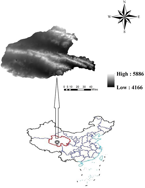
FIGURE 1. Locations of study area.
Data processing
The importance value (IV) is used as the dominance index of species in the community and calculated as:
The classification was based on the important values of the species represented by the average values of the three samples. The vegetation assemblages were classified by TWINSPAN (two-way indicator species analysis) in WinTWINS version 2.3. To identify the correlation of floristic data with environmental gradients, DCA (Detrended correspondence analysis), CCA (Canonical Correlation Analysis) ordination was carried out using the program Canoco5.0 for Windows. Species important values and environmental variables, including elevation, slope, aspect, and slope position, which were log transformed before statistical analysis to ensure homogeneity of variance. Manual forward selection through a Monte Carlo permutation test with 499 permutations (p < 0.05 significance) was performed to select the environmental variables explaining species composition. Species which occurred once only were omitted from the analysis.
Results
Characteristics of plant communities
In total, 29 plant species belonging to 27 genera and 16 families were identified (Table 1). At the family level, Gramineae, Compositae, Scrophulariaceae were larger families, accounting for 17.24% (5 species), 11.1% (3 species), 11.1% (3 species). Vegetation composition varies significantly under different topographic conditions. The number of plant species in hilly sloppy is up to 18 and in foothill is at least 14. L. chinensis, E. dahuricus and C. declinatum are the dominant species of sandy alpine grassland in the source regions of Yangtze River.
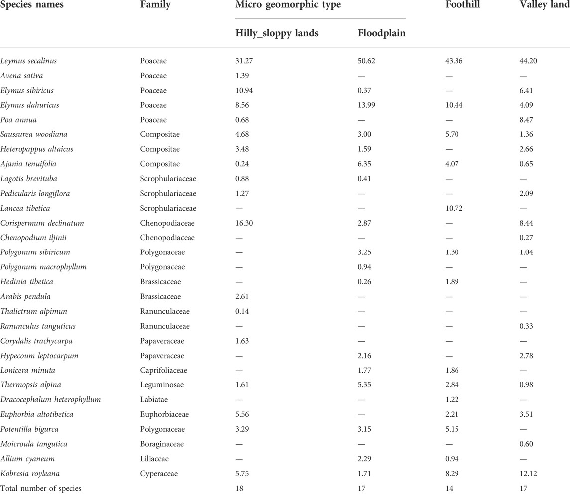
TABLE 1. Species important value of sandy alpine grassland community in different microtopography.
The standard frequency distribution of species based on the C. Raunkiaer methods is shown in (Figure 2). The number of grade species in hilly sloppy land, floodplain, foothill, valley land ranked as A > B > D, A>C>B = D = E, A > B=C > E, A > B > C = D = E respectively. The lack of E-class species is implying that the community of hilly sloppy land is in a high succession stage. In terms of species composition, the proportion of dominant species is lower than rare species. There are 2 species appearing in C, D, and E grades of four landforms, which is L. secalinus and E. dahuricus, the average frequency of which are 40% or more, respectively. There are four kinds of B-class species with an average frequency between 20% and 40%, which are E. altotibetica, K. royleana, C. declinatum, and A. tenuifolia. The rare species accounted for 48.23% of the total species.
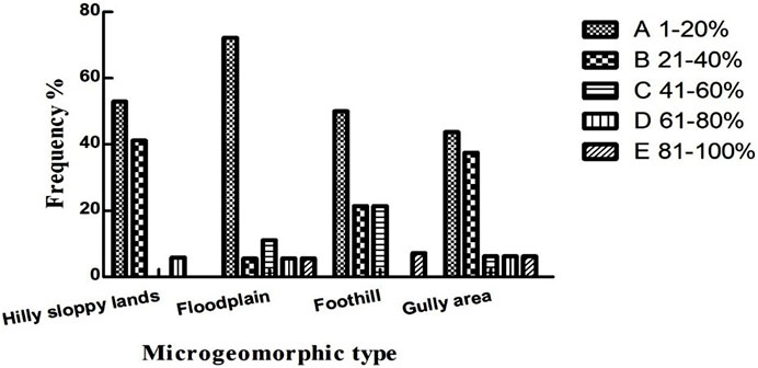
FIGURE 2. The distribution of standard frequency of species referring to the Raunkiaer’s law.
Classification of plant community
Based on the 3rd level of division in TWINSPAN classification, seven interpretable groups of plant communities were discriminated (Figure 3). The plant communities were separated into main associations: AssI. L.secalinus+H. altaicus+S. woodiana mainly distributed on the bottom and leeward of sandy hilly sloppy land, accompanying species include E. altotibetica, P. bifurca, and P. annua. AssII. L. secalinus+K. royleana+ C. declinatum mainly grow on upper part and windward of sandy hilly sloppy land, accompanying species include E. altotibetica, P. bifurca, and Lancea tibetica. AssIII. L. secalinus+E. dahuricus+A. tenuifolia represented the habitat of sandy floodplain, accompanied by C. declinatum, A. cyaneum, P. sibiricum, S. woodiana, and K. royleana. AssIV. L. secalinus+Thermopsis alpina mainly distributed in top of sandy hilly sloppy land, and accompanied by C. declinatum, P. longiflora. AssV. E. sibiricus+P. annua grow on the leeward of sandy foothill, accompanying species include L. secalinus, E. dahuricus, C. declinatum and K. royleana. AssVI. Elymus sibiricus+E. dahuricus mainly distributed in the leeward of sandy gully land, and companied by C. declinatum, C. trachycarpa and L. brevituba. AssVII. C. declinatum distributed in the windward of sandy gully land
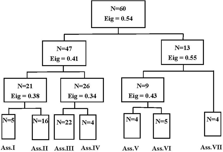
FIGURE 3. Dendrogram of TWINSPAN (two-way indicator species analysis) classification for plant species. (Note: Eig = Eigenvalue).
Ordination of plant community
It was well known that DCA can be used to estimate the variation of species composition along the environment gradient, providing gradient length reference for communities’ ordination. The cluster types obtained by TWINSPAN classification are basically consistent with the DCA ordination. The DCA results show that the eigenvalues of the four ordination axes are 0.56, 0.28, 0.23, and 0.17, respectively. The eigenvalues of the first two ordination axes are large, showing important ecological significance (Figure 4). The DCA ordination of sandy alpine communities shows that the maximum gradient length is 3.93 (Table 2). When the DCA gradient length was between 3 and 4, there was no difference between linear and unimodal models in the community’s ordination. Therefore, CCA was selected to identify the relationship between species distribution and environmental factors.
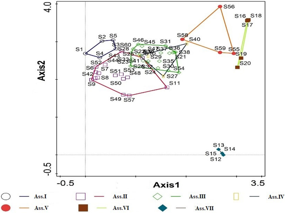
FIGURE 4. DCA two-dimensional ordination diagram for samples of sandy alpine grassland community.
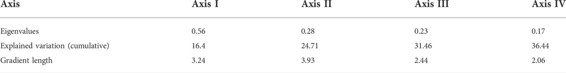
TABLE 2. The DCA analysis of the species variance of sandy alpine grassland communities.
The results of Monte Carlo test show that all the canonical ordination axes pass the statistical test (F = 1.85, p = 0.002), indicating that the topographic factor has a significant impact on the distribution of plant species in the Qidukou sandy alpine grasslands. The axes of CCA ordination represent the gradient changes of different topographic factors. According to the correlation between topographic factors and CCA ordination axis, altitude, slope, aspect and slope position are significantly positively correlated with the CCA axis I. The correlation size is graded as slope > slope position > altitude > aspect, indicating that the CCA axis I mainly reflects the gradient change of the slope. The aspect, altitude, slope, and slope position were significantly positively correlated with the CCA axis II. The correlation order was sorted as aspect > altitude > slope > slope position, indicating that the CCA axis2 mainly represented the aspect gradient (Table 3). The results of forward selection show that the slope is the most important topographical factor for the distribution of plant species in the sandy alpine grasslands, followed by the aspect, altitude, and slope position (Table 4).
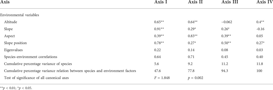
TABLE 3. The CCA analysis of the species variance of sandy alpine grassland communities.
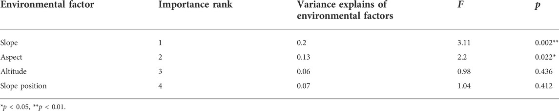
TABLE 4. Rank of importance and significance test of environmental factors.
The CCA ordination of species-environmental factor visually indicates the relationship between the species distribution of sandy alpine grassland and topographic factors (Figure 5). The first two axis of CCA ordination represents the slope and aspect gradient. A. pendula, E. altotibetica, K. royleana and P. longiflora are distributed on the upper right side of the CCA ordination diagram, which is greatly affected by slope and aspect. The D. heterophyllum, P. bifurca, and L. tibetica are distributed at the left end of the first axis, its distribution is less affected by slope. The C. declinatum and L. brevituba are distributed on the lower right side of the CCA ordination diagram, which is greatly affected by the slope. P. annua, M. tibetica, A. cyaneum, A. tenuifolia and L. minuta are located at the lower and left of the CCA ordination, which is less affected by slope and aspect, and is mainly distributed in the flat floodplain.
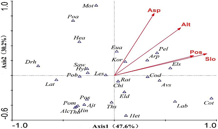
FIGURE 5. CCA two-dimensional ordination diagram for species and environmental variables of alpine grassland communities. Note: Arrows represent environmental factors, Asp: Aspect; Alt: Altitude; Pos: Slope Position; Slo: Slopes. Triangle represents plant species, Les:Leymus secalinus; Avs: Avena sativa; Els:Elymus sibiricus; Eld: Elymus dahuricus; Poa:Poa annua; Saw:Saussurea woodiana; Hea:Heteropappus altaicus; Ajt:Ajania tenuifolia; Lab:Lagotis brevituba; Pel:Pedicularis longiflora; Lat:Lancea tibetica; Cod:Corispermum declinatum; Chi:Chenopodium iljinii; Pos:Polygonum sibiricum; Pom:Polygonum macrophyllum; Het:Hedinia tibetica; Arp:Arabis pendula; Tha:Thalictrum alpimun; Drh:Dracocephalum heterophyllum; Eua:Euphorbia altotibetica; Pob:Potentilla bigurca; Mot:Moicroula tangutica; Alc:Allium cyaneum; Kor:Kobresia royleana.
Discussion
Characteristics of sandy alpine grassland communities
Plants are the most sensitive and intuitive signs in all stages of desertification development. The development of desertification is closely linked to the changes in vegetation and succession simultaneously (Shao, et al., 1988). The retrograde and progressive succession of plant communities essentially correspond to the positive and negative processes of desertification (Zhao and Zhao 2000). With the increase of desertification degree, the density of soil seed bank decreased, the community diversity decreased significantly, and the grassland vegetation showed ecological adaptability to cold, drought and grazing stress (Zhao et al., 2003). The community structure tends to be simple, and the dominant species and associated species of typical alpine meadows gradually withdraw from the community, while the species adapted to sandy deserts gradually occupy the dominant position in the community, and the shrub invasion is obvious (Li et al., 2014). Succession transition pattern of hygrophytes, mesophytes, and xerophytes was appeared in the communities (Wang T. et al., 2013). With the increase of grassland desertification, the vegetation composition changed, the perennial herb plants gradually decreased, and the annual herbaceous plants showed a trend of increasing. The moderate desertification stage is an important turning point for the change of grassland plant community characteristics (Mao et al., 2014). The sandy alpine grassland community in Qidukou of the Yangtze River source region showed similar law: 29 plant species belonged to 16 families and 27 genera, and single species families accounted for 27.59%. Drought-tolerant plant species such as L. chinensis, A. tenuifolia, and C. declinatum have gradually replaced zonal grassland plants such as S. woodiana, p. bifurca, and P. longiflora, and the proportion of dominant species is lower than that of rare species and annual herb. Mainly, the vegetation community is in a high succession stage. The gradual decrease of edible pastures such as Gramineae and Cyperaceae and the sharp increase of forb cover reflect the basic characteristics of vegetation changes during the degradation succession of alpine meadows (Wang X. M., 2013). The dominant species of L. chinensis in the desertified grassland of Qidukou is distributed in large quantities, which is similar to the law of vegetation differentiation of the sandy alpine grassland in the Ruergai (Li et al., 2013). The desertification of grassland has led to the expansion of semi-fixed sand area and patchy distribution. As a typical clonal plant, L. chinensis is a representative and widely distributed rhizomatous grass in sandy habitat, and the bare sand patchy formed by wind erosion is used as a resource for rhizome expansion. As the grassland degradation process intensifies, the L. chinensis population is dominated by the aggregative pattern, which reflects the cooperative relationship between the species (Ren and Zhao, 2013). The expansion of L. chinensis, the emergence of indicator species such as the poisonous weeds A. tenuifolia, and psammophyte C. declinatum, indicate that the desertification of the alpine grassland in Qidukou is progressing, and the vegetation community is succeeding in the direction of xerophytes.
Relationship between vegetation and desertification
The desertification of alpine grassland is a process of soil coarse texture, desiccation and poor fertility, accompanied by a decrease in soil carbon sequestration potential (Jin et al., 2015). The wind erosion and aeolian landforms formed by sand drift activity are important carriers for the survival and development of sandy vegetation. During the strong sand activity period, fine particulate matter is transported, eroded, surface roughened, fixed, and semi-fixed dunes evolve to semi-flow and mobile dunes, and wind erosion takes away the fine particulate matter required for vegetation growth (Chepil and Woodruff 1963). During the weak sand activity period, fine particulate matter slowly accumulates around the vegetation, and promotes the development of vegetation (Lancaster and Baas 1998). Wind erosion and sand burial regulate photosynthetic and transpiration rate through leaf water potential, leaf water content and stomatal conductance, and ultimately affect the water use efficiency of Alhagi sparsifolia, As the degree of sand fixation increases, Corispermum patelliforme tend to use more resources and energy for reproductive growth (Ma et al., 2014). The aeolian landform process is closely related to soil and vegetation succession changes at different spatial and temporal scales (Okin et al., 2006), forming a complex dynamic and crossfeed biogeography system (Hesp et al., 2011).
Driving mchanism of vegetation sucession
Soil seed banks play an important role in community succession, renewal, and ecological restoration in desert steppe areas. In the same climatic zone, topography has a direct impact on soil seed bank, which ultimately leads to changes in vegetation patterns. The reserves of soil seed bank from the top to the bottom slope show an overall increase trend (Han et al., 2014). With the fixation of sand dunes, the density of soil seed banks gradually increased, species diversity increased, and species distribution became more uniform. Dune types and slope positions lead to different soil seed bank densities (Zhao et al., 2007; Yu et al., 2015). With the increase of desertification degree, the density of soil seed bank decreased, the community diversity decreased significantly, and the grassland vegetation showed ecological adaptability to cold, drought and grazing stress (Zhao et al., 2003). The contribution rate of seed bank to vegetation restoration of sand dune ecosystem varies with dune types. The coupling relationship between natural physical process of dune ecosystem and seed bank is an important research direction in the future (Tang and Liu 2012). The aeolian landform process regulates the species distribution of grassland vegetation communities by affecting soil nutrients, leaf water physiology, individual survival strategies and seed bank density (He et al., 2009). This study found that the standard frequency distribution of species varies in different topography. The proportion of dominant species is lower than that of rare species. The species diversity in study region ranked as hilly sloppy lands > floodplain = valley land > foothill, reflecting an important role of the micro-geomorphology in the species distribution of sandy grassland communities.
In general, topographic factors include altitude, slope, aspect, slope position affecting the distribution pattern of species through the redistribution of matter and energy (Cantón et al., 2004), and is also an important factor affecting the process of aeolian landforms. Slope is the driving force of water and soil nutrient flow in the horizontal direction, and has a significant impact on soil thickness and physical and chemical properties. The slope increases the component force of the soil particles along the slope, which affects the wind erosion of the slope surface (He et al., 2010). The rate of wind erosion increases with the slope, which caused the spatial heterogeneity of vegetation in the windward of fixed dune (Zhao et al., 2011). The results of the research on alpine meadows in the source area of the Lantsang is consistent with this paper that slope is the most important topographic factor for the distribution of plant species in the sandy alpine (Zhang et al., 2012). Aspect affects the composition and distribution of vegetation community by affecting light, temperature, and soil nutrients (Xu 2016). The quantitative characteristics and diversity index of herbaceous vegetation on the leeward slope were larger than that of the windward slope in the Hunshadake Sandy Land (Bai et al., 2015). The aspect and slope position of the dunes have significant effects on the alpha diversity of the herbaceous plants and the spatiotemporal pattern of β diversity in the Gurbantunggut desert (Jia et al., 2018). The soil moisture conditions in the interdune are the best, followed by the middle slope and the lowest on the top slope (Huang et al., 2009). Due to the influence of microtopography, rainfall recharge is the highest in the lowland. Soil water at dune top and up slope was in deficit during no rain for long time (Zhou et al., 2017). In the alpine meadow of Tibetan Plateau, the physical and chemical properties of soils under different topography have significant effects on the functional traits and diversity of plant communities (Li 2016). This study showed that slope and aspect have a significant impact on the species distribution of desertified grassland. In summary, due to the differences in research scales and regional natural geographical conditions, the topographical factors of altitude, slope, aspect, and slope position have different effects on the distribution of plant species.
Conclusion
The community structure of desertified grassland is simple. L. chinensis, E. dahuricus and C. declinatum are the dominant species of sandy alpine grassland in the source regions of Yangtze River. The species composition of sandy grassland is varied with microtopography. The proportion of dominant species is lower than rare species, suggesting that the community is in a high succession stage. The expansion of C. declinatum indicates that the desertification of the alpine grassland is progressing, and the vegetation community is succeeding in the direction of xerophytic. CCA ordination reflected that slope and aspect are the dominant factors among microtopography determining the species distribution of sandy alpine grassland.
The artificial restoration and reconstruction of sandy alpine grassland should firstly pay attention to the selection and utilization of native species, and then fully exploit the potential of soil seed bank in grassland restoration. Finally, the relationship between aeolian landform process and vegetation succession and favorable natural landforms for grassland restoration should be considered. Based on the aeolian landform, the comprehensive measures of engineering and biology are combined to achieve the restoration of sandy alpine grasslands.
Data availability statement
The raw data supporting the conclusion of this article will be made available by the authors, without undue reservation.
Author contributions
PZ and XX conceived and designed the experiments; JT and SJ performed the sample collection; and PZ analyzed the data and wrote the paper. All authors read and approved the paper before submission.
Funding
This work was financially supported by the National Key R&D Program of China [grant No.2017YFC0504804], the National Natural Science Foundation of China (Grant Nos. 42207109, 32060246), the Gansu Province Youth Science and Technology Talents Lifting Project (2020-104-17), Longyuan Youth Innovation and Entrepreneurship Talents Project (2022LQGR21), the Open Project of Key Laboratory of Desert and Desertification, Chinese Academy of Sciences (KLDD-2020-017) and the Qingshan Guard Action Project of China Environmental Protection Foundation (CEPFQS202169-21).
Conflict of interest
The authors declare that the research was conducted in the absence of any commercial or financial relationships that could be construed as a potential conflict of interest.
Publisher’s note
All claims expressed in this article are solely those of the authors and do not necessarily represent those of their affiliated organizations, or those of the publisher, the editors and the reviewers. Any product that may be evaluated in this article, or claim that may be made by its manufacturer, is not guaranteed or endorsed by the publisher.
References
Bai, H. M., Li, G. T., Ma, J. J., Li, Y. J., and Liang, T. Y. (2015). Differentiation of micro-landform vegetation characteristics in Hunshadake sandy land. North. Hourticulture 17, 53–57. (in Chinese). doi:10.11937/bfyy.201517014
Cantón, Y., Del Barrio, G., Solé-Benet, A., and Lázaro, R. (2004). Topographic controls on the spatial distribution of ground cover in the Tabernas badlands of SE Spain. Catena 55 (3), 341–365. doi:10.1016/S0341-8162(03)00108-5
Chepil, W. S., and Woodruff, N. P. (1963). The physics of wind erosion and its control. Adv. Agron. 15, 211–302. doi:10.1016/S0065-2113(08)60400-9
Cui, X. F., and Graf, H. (2009). Recent land cover changes on the Tibetan plateau: A review. Clim. Change 94, 47–61. doi:10.1007/s10584-009-9556-8
Dong, Y. X. (1999). Progresses and problems in research on sandy desertification in qinghai-xizang plateau. J. desert Res. 19 (3), 251–255. (in Chinese). doi:10.3321/j.issn:1000-694X.1999.03.012
Dong, Z. B., Hu, G. Y., Qian, G. Q., Lu, J. F., Zhang, Z. C., Luo, W. Y., et al. (2017). High-altitude aeolian research on the Tibetan Plateau. Rev. Geophys. 55 (4), 864–901. doi:10.1002/2017rg000585
Dong, Z. B., Hu, G. Y., Yan, C. Z., Wang, W. L., and Lu, J. F. (2010). Aeolian desertification and its causes in the zoige plateau of China's Qinghai-Tibetan plateau. Environ. Earth Sci. 59, 1731–1740. doi:10.1007/s12665-009-0155-9
Du, Y. G., Cui, J. Y., Ge, J. S., Zhao, X. D., Ren, J., and Wang, Y. (2010). Community characteristics study on alpine grassland in source regions of three rivers. Pratacultural Sci. 27 (3), 9–14. (in Chinese).
Duran, O., and Herrmann, H. J. (2006). Vegetation against dune mobility. Phys. Rev. Lett. 97 (18), 188001. doi:10.1103/PhysRevLett.97.188001
Fand, K., Song, N. P., Wei, L., and An, H. (2012). Spatiotemporal distribution of soil moisture content and aboveground biomass under different terrains in desert steppe. Arid Zone Res. 29 (4), 641–647. (in Chinese). doi:10.13866/j.azr.2012.04.012
Gao, Y. H., Li, X., Leung, L. R., Chen, D. L., and Xu, J. W. (2015). Aridity changes in the Tibetan Plateau in a warming climate. Environ. Res. Lett. 10 (3), 034013. doi:10.1088/1748-9326/10/3/034013
Han, R. Y., Chen, Y. Y., and Li, W. X. (2014). The distribution and relationships of ground vegetation, soil seed bank and soil water content of fixed sand under different micro-landform condition. Pratacultural Sci. 31 (10), 1825–1832. 10.11829\j.issn.1001-0629.2014-0164. (in Chinese).
He, J. J., Tang, Z. J., and Cai, Q. G. (2010). Study on changing laws of soil wind erosion by wind tunnel experiment in Agro-pastoral area of Inner Mongolia. J. Soil Water Conservation 24 (4), 35–39. (in Chinese). doi:10.13870/j.cnki.stbcxb.2010.04.017
He, Y. H., Zhao, H. L., Liu, X. P., Zhao, X. Y., Li, Y. L., and Zhao, W. (2009). Reproductive allocation and its relationship with the size of Corispermum elongatum in different sandy habitats. Arid Zone Res. 26 (1), 59–64. (in Chinese). doi:10.3724/sp.j.1148.2009.00059
Hernández-Cordero, A. I., Hernández-Calvento, L., and Perez-Chacon Espino, E. (2015). Relationship between vegetation dynamics and dune mobility in an arid transgressive coastal system, Maspalomas, Canary Islands. Geomorphology 238, 160–176. doi:10.1016/j.geomorph.2015.03.012
Hesp, P., Martinez, M., da Silva, G. M., Rodríguez-Revelo, N., Gutierrez, E., Humanes, A., et al. (2011). Transgressive dunefield landforms and vegetation associations, Doña Juana, Veracruz, Mexico. Earth Surf. Process. Landf. 36, 285–295. doi:10.1002/esp.2035
Huang, G., Zhao, X. Y., Huang, Y. X., and Su, Y. G. (2009). Soil moisture dynamics of artificial Caragana microphylla shrub at different topographical sites in Horqin land. Chin. J. Appl. Ecol. 20 (3), 555–561. (in Chinese). doi:10.13287/j.1001-9332.20090108
Jia, F. Q., Ren, J. J., and Zhang, Y. M. (2018). Effect of slope aspect and terrain of sand dune on herbaceous diversity in Gurbantunggut desert. Chin. J. Ecol. 37 (1), 26–34. (in Chinese). doi:10.13292/j.1000-4890.201801.031
Jin, H. X., He, F. L., Li, C. L., Han, S. H., and Wang, Q. Q. (2015). Vegetation characteristics, abundance of soil microbes, and soil physico-chemical properties in desertified alpine meadows of Maqu. Acta Prataculturae Sin. 24 (11), 20–28. (in Chinese). doi:10.11686/cyxb201513
Lancaster, N., and Baas, A. (1998). Influence of vegetation cover on sand transport by wind: Field studies at owens lake, California. Earth Surf. Process. Landf. 23 (1), 69–82. doi:10.1002/(sici)1096-9837(199801)23:1<69::aid-esp823>3.0.co;2-g(199801)23:1<69::Aid-esp823>3.0.Co;2-g
Li, C. L., Xu, X. Y., Jin, H. X., Wang, D. Z., and Li, J. J. (2014). Community structures and plant diversities in the desertification process of Maqu alpine meadow in Gansu. Acta eco. Sin. 34 (14), 3953–3961. (in Chinese). doi:10.5846/stxb201212021725
Li, X. L., Gao, J., Brierley, G., Qiao, Y. M., Zhang, J., and Yang, Y. W. (2013). Rangeland degradation on the Tibetan plateau: Implications for rehabilitation. Land Degrad. Dev. 24 (1), 72–80. doi:10.1002/ldr.1108
Li, Z. (2016). Plant functional traits and functional diversity response to topographical changes. Lanzhou: Lanzhou University.
Ma, Y., Wang, X. Q., Zhang, B., Liu, J. H., Han, Z. Y., and Tang, G. L. (2014). Effects of wind erosion and sand burial on water relations and photosynthesis in Alhagi sparsifolia in the southern edge of the Taklimakan Desert. Chin. J. Plant Ecol. 38 (5), 491–498. (in Chinese). doi:10.3724/SP.J.1258.2014.00045
Mao, S. H., Xie, Y. Z., and Xu, D. M. (2014). Impact of grassland desertification on vegetation and soil properties in Yanchi county of Ningxia Hui Autonomous region. Bull. soil water conservation 34 (1), 34–39. (in Chinese). doi:10.13961/j.cnki.stbctb.2014.01.060
Miehe, G., Bach, K., Miehe, S., Kluge, Y., Yang, Y. P., La, D., et al. (2011). Alpine steppe plant communities of the Tibetan highlands. Appl. Veg. Sci. 14, 547–560. doi:10.1111/j.1654-109X.2011.01147.x
Okin, G. S., Gillette, D. A., and Herrick, J. E. (2006). Multi-scale controls on and consequences of aeolian Processes in landscape change in arid and semi-arid environments. J. Arid Environ. 65, 253–275. doi:10.1016/j.jaridenv.2005.06.029
Ren, H., and Zhao, C. Z. (2013). Spatial pattern and competition relationship of Stellera chamaejasme and Aneurolepidium dasystachys population in degraded alpine grassland. Acta eco. Sin. 33 (2), 435–442. (in Chinese). doi:10.5846/stxb201112031850
Shao, L. Y., Dong, G. R., and Lu, F. G. (1988). Developmental and adverse process of steppe desertification and law of vegetation succession in Gonghe Basin. J. Desert Res. 8 (1), 30–40. (in Chinese).
Stallins, J. A. (2006). Geomorphology and ecology: Unifying themes for complex systems in biogeomorphology. Geomorphology 77, 207–216. doi:10.1016/j.geomorph.2006.01.005
Tang, Y., and Liu, Z. M. (2012). Advances, trends and challenges in seed bank research for sand dune ecosystems. Chin. J. Plant Ecol. 36 (8), 891–898. (in Chinese). doi:10.3724/SP.J.1258.2012.00891
Urant, S., Zhang, D. P., Wu, X. D., Yang, R. R., and Huang, X. W. (2008). Analysis on plant communities in a depression in Hulunbuir sandy meadow grassland, Inner Mongolia, China. J. Desert Res. 28 (6), 1125–1129. (in Chinese).
Wang, H., Zhou, X. L., Wang, C. G., Fu, H., Zhang, F., and Ren, J. Z. (2008). Eco-environmental degradation in the northeastern margin of the Qinghai-Tibetan Plateau and comprehensive ecological protection planning. Environ. Geol. 55 (5), 1135–1147. doi:10.1007/s00254-007-1061-7
Wang, J. B., Zhang, D. Z., Cao, G. M., and Tian, Q. (2013). Regional characteristics of the alpine meadow degradation succession on the Qinghai-Tibetan plateau. Acta Prataculturae Sin. 22 (2), 1–10.
Wang, T., Tu, W. G., Xi, H., Li, Y. D., Tang, X. F., and Yang, Y. C. (2013). Study on vegetation and soil characteristics of desertification grassland in northwest Sichuan. Acta Agrestia Sin. 21 (4), 650–657. doi:10.11733/j.issn.1007-0435.2013.04.004
Wang, X. M., Liu, Z. M., Liu, B., and Yan, S. G. (2010). Interspecific associations of plants in interdune lowland of mobile and stabilized dunes in eastern Inner Mongolia of China. J. Ecol. 29 (1), 16–21. (in Chinese). doi:10.13292/j.1000-4890.2010.0039
Wang, X. M. (2013). Sandy desertification: Borne on the wind. Chin. Sci. Bull. 58 (20), 2395–2403. doi:10.1007/s11434-013-5771-9
Xu, C. L. (2016). Variations in vegetation composition and nutrient characteristics related to aspect in an alpine meadow in the northeast margin of the Qinghao-Tibet plateau. Acta Prataculturae Sin. 25 (4), 26–35. (in Chinese). doi:10.11686/cyxb2015481
Xu, X. L., Wang, L., Li, J., and Cai, H. Y. (2017). Analysis of the grassland restoration trend and degradation situation in the “Three-River Headwaters” region since the implementation of ecological project. J. Geo-information Sci. 19 (1), 50–58. (in Chinese). doi:10.3724/SP.J.1047.2017.00050
Xu, Y. M., and Lv, S. H. (2011). Effects of wind erosion desertification on the biodiversity of grassland vegetation of Hulunbuir steppe. J. Arid Land Resour. Environ. 25 (4), 133–137. doi:10.13448/j.cnki.jalre.2011.04.026
Xue, X., Guo, J., Han, B. S. A., Sun, Q. W., and Liu, L. C. (2009). The effect of climate warming and permafrost thaw on desertification in the Qinghai-Tibetan Plateau. Geomorphology 108, 182–190. doi:10.1016/j.geomorph.2009.01.004
Yan, P., Dong, G. R., Su, Z. Z., and Zhang, D. D. (2004). Desertification problems in the Yangtze River source area, China. Land Degrad. Dev. 15 (2), 177–182. doi:10.1002/ldr.602
Yan, P., Dong, G., Zhang, X., and Zhang, Y. (2000). Preliminary results of the study on wind erosion in the Qinghai-Tibetan Plateau using137Cs technique. Chin. Sci. Bull. 45, 1019–1025. doi:10.1007/BF02884984
Yang, M., Nelson, F., Shiklomanov, N., Guo, D., and Wan, D. (2010). Permafrost degradation and its environmental effects on the Tibetan plateau: A review of recent research. Earth-Science Rev. 103, 31–44. doi:10.1016/j.earscirev.2010.07.002
Yu, J., Gao, L., Yan, Z. J., and Wang, S. Q. (2015). Characteristics of soil seed bank of sand dune in different succession stages in the eastern KUbuqi desert. Chin. J. Grassl. 37 (4), 80–85. (in Chinese).
Zhang, C. S., Xie, G. D., Bao, W. K., Chen, L., Pei, S., and Fan, Na. (2012). Effects of topographic factors on the plant species richness and distribution pattern of alpine meadow in source region of Lancang river, southwest China. Chin. J. Ecol. 31 (11), 2762–2774. (in Chinese). doi:10.13292/j.1000-4890.2012.0443
Zhang, P., Kang, J. L., Yuan, Z., Tang, J., Hao, L. X., and Jin, L. (2017). Similarities and difference of the plant communities on two vegetation-dunes and their response to dune morphology. Acta Ecol. Sin. 37 (23), 7920–7927. (in Chinese). doi:10.5846/stxb201610262182
Zhao, C. Y., and Wang, T. (2005). Current research status and prospects of vegetation succession on sandy land during its desertification process in semiarid regions of China. Chin. J. Ecol. 24 (11), 1343–1346. (in Chinese). doi:10.13292/j.1000-4890.2005.0157
Zhao, C. Y., Wang, T., Dong, Z. B., Zhao, X. Y., and Xue, X. (2007). Plant diversity and its relationship with habitat in Korqin sandy land. Pratacultural Sci. 24 (10), 11–18. (in Chinese).
Zhao, G. H., Dan, Z. T. Q., and Wei, X. H. (2012). A review grassland desertification characteristic of Qinghai-Tibet Plateau. Grassl. Turf 32 (5), 83–89. (in Chinese). doi:10.13817/j.cnki.cyycp.2012.05.020
Zhao, H. L., Zhou, R. L., Wang, J., Zhao, X. Y., and Zhang, D. H. (2011). Desertificaton process and its mechanism of steppe vegetation in the Hulumbuir sandy steppe, Inner Mongolia. Arid Zone Res. 28 (4), 565–571. (in Chinese). doi:10.3724/SP.J.1011.2011.00110
Zhao, L. Y., Li, F. R., and Wang, X. Z. (2003). Characteristics of soil seed bank and standing vegetation change in sandy grasslands along a desertification gradient. Acta Ecol. Sin. 23 (9), 1745–1756. (in Chinese).
Zhao, L. Y., and Zhao, H. L. (2000). A brief review on vegetation succession research in desertification processes of China. J. Desert Res. 20 (1), 8–15. (in Chinese).
Keywords: species distribution, TWINSPAN, DCA, CCA, microtopography, sandy alpine grassland
Citation: Zhao P, Xu X, Tang J and Jiang S (2022) Relationship between species distribution of sandy alpine grasslands and microtopography in the source regions of Yangtze river. Front. Environ. Sci. 10:934483. doi: 10.3389/fenvs.2022.934483
Received: 02 May 2022; Accepted: 14 September 2022;
Published: 31 October 2022.
Edited by:
Hamid Gholami, University of Hormozgan, IranReviewed by:
Shengbo Xie, Northwest Institute of Eco-Environment and Resources (CAS), ChinaXiaojing Qin, Henan Polytechnic University,China
Copyright © 2022 Zhao, Xu, Tang and Jiang. This is an open-access article distributed under the terms of the Creative Commons Attribution License (CC BY). The use, distribution or reproduction in other forums is permitted, provided the original author(s) and the copyright owner(s) are credited and that the original publication in this journal is cited, in accordance with accepted academic practice. No use, distribution or reproduction is permitted which does not comply with these terms.
*Correspondence: Xianying Xu, xyingxu@163.com