
Size of this preview: 635 × 600 pixels. Other resolutions: 254 × 240 pixels | 508 × 480 pixels | 813 × 768 pixels | 1,154 × 1,090 pixels.
Original file (1,154 × 1,090 pixels, file size: 533 KB, MIME type: image/png)
| This is a file from the Wikimedia Commons. Information from its description page there is shown below. Commons is a freely licensed media file repository. You can help. |
Summary
| Description |
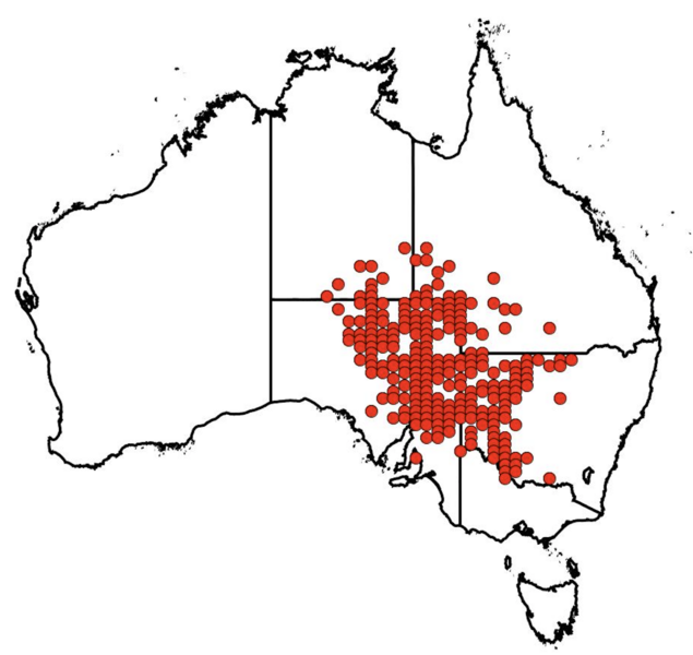
English: Distribution map of recorded occurrences of A. angulata as found on the Atlas of Living Australia website. |
| Date | |
| Source | https://biocache.ala.org.au/occurrences/search?q=lsid:https://id.biodiversity.org.au/node/apni/2887187#tab_mapView |
| Author | OpenStreetMap |
Licensing
This file is licensed under the Creative Commons Attribution 4.0 International license.
- You are free:
- to share – to copy, distribute and transmit the work
- to remix – to adapt the work
- Under the following conditions:
- attribution – You must give appropriate credit, provide a link to the license, and indicate if changes were made. You may do so in any reasonable manner, but not in any way that suggests the licensor endorses you or your use.
File history
Click on a date/time to view the file as it appeared at that time.
| Date/Time | Thumbnail | Dimensions | User | Comment | |
|---|---|---|---|---|---|
| current | 10:56, 12 June 2023 | | 1,154 × 1,090 (533 KB) | FieldEcology33 | Uploaded a work by OpenStreetMap from https://biocache.ala.org.au/occurrences/search?q=lsid:https://id.biodiversity.org.au/node/apni/2887187#tab_mapView with UploadWizard |
File usage
The following pages on the English Wikipedia use this file (pages on other projects are not listed):