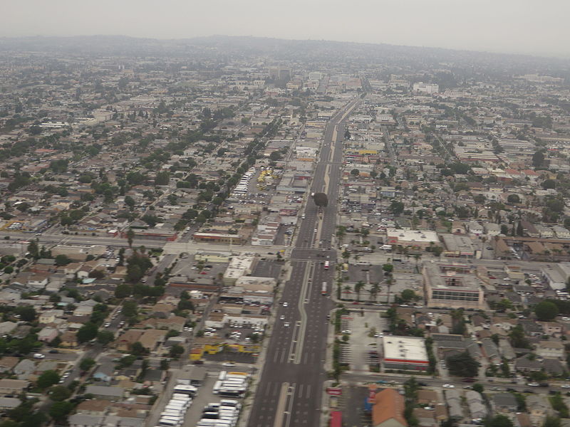
File:La Brea Avenue, Inglewood, California (14516651172).jpg

Original file (4,000 × 3,000 pixels, file size: 3.17 MB, MIME type: image/jpeg)
Captions
Captions
Summary[edit]
| DescriptionLa Brea Avenue, Inglewood, California (14516651172).jpg |
La Brea Avenue is a prominent north/south thoroughfare in Los Angeles. Several museums are located along La Brea, and it is known for having many stores and eateries. La Brea Avenue begins as a continuation of Hawthorne Boulevard north of Century Boulevard in Inglewood. La Brea passes north through Windsor Hills, Baldwin Hills, and Ladera Heights. It passes directly through the Kenneth Hahn State Recreation Area. Further north, La Brea passes the Fairfax District, the Mid-City West District, Park La Brea, and Hancock Park; and ends just north of Franklin Avenue at the foot of the Hollywood Hills, in Hollywood. "La Brea" is Spanish for "the tar", a reference to the La Brea Tar Pits. La Brea near Wilshire is home to Museum Row, including landmarks such as the Los Angeles County Museum of Art, the La Brea Tar Pits, and the George C. Page Museum. La Brea north of Wilshire Boulevard and south of Melrose Avenue is filled with trendy designer boutiques, antique stores, and eateries. The famed La Brea Bakery is located between Wilshire and 6th, on La Brea. La Brea is also home to The Lyric Theatre and Pink's Hot Dogs. It also marks the eastern boundary between West Hollywood and Los Angeles. The section of La Brea in Inglewood was known in its early history as Commercial Street. In its northern-most reaches, La Brea was Arroyo La Brea, coming from a (now capped) spring in the Santa Monica Mountains. That is what helped form the original reservoir in what is now Kenneth Hahn State Recreation Area. en.wikipedia.org/wiki/La_Brea_Avenue en.wikipedia.org/wiki/Wikipedia:Text_of_Creative_Commons_... |
| Date | |
| Source | La Brea Avenue, Inglewood, California |
| Author | Ken Lund from Reno, Nevada, USA |
| Camera location | 33° 56′ 43.76″ N, 118° 21′ 09.57″ W | View this and other nearby images on: OpenStreetMap |
|---|
Licensing[edit]
- You are free:
- to share – to copy, distribute and transmit the work
- to remix – to adapt the work
- Under the following conditions:
- attribution – You must give appropriate credit, provide a link to the license, and indicate if changes were made. You may do so in any reasonable manner, but not in any way that suggests the licensor endorses you or your use.
- share alike – If you remix, transform, or build upon the material, you must distribute your contributions under the same or compatible license as the original.
| This image was originally posted to Flickr by Ken Lund at https://flickr.com/photos/75683070@N00/14516651172. It was reviewed on 4 December 2015 by FlickreviewR and was confirmed to be licensed under the terms of the cc-by-sa-2.0. |
4 December 2015
File history
Click on a date/time to view the file as it appeared at that time.
| Date/Time | Thumbnail | Dimensions | User | Comment | |
|---|---|---|---|---|---|
| current | 03:59, 4 December 2015 |  | 4,000 × 3,000 (3.17 MB) | INeverCry (talk | contribs) | Transferred from Flickr via Flickr2Commons |
You cannot overwrite this file.
File usage on Commons
The following page uses this file:
File usage on other wikis
The following other wikis use this file:
- Usage on pl.wikipedia.org
- Usage on www.wikidata.org
Metadata
This file contains additional information such as Exif metadata which may have been added by the digital camera, scanner, or software program used to create or digitize it. If the file has been modified from its original state, some details such as the timestamp may not fully reflect those of the original file. The timestamp is only as accurate as the clock in the camera, and it may be completely wrong.
| Camera manufacturer | Canon |
|---|---|
| Camera model | Canon PowerShot SX280 HS |
| Exposure time | 1/40 sec (0.025) |
| F-number | f/4 |
| ISO speed rating | 80 |
| Date and time of data generation | 06:51, 26 June 2014 |
| Lens focal length | 8.044 mm |
| Orientation | Normal |
| Horizontal resolution | 180 dpi |
| Vertical resolution | 180 dpi |
| File change date and time | 06:51, 26 June 2014 |
| Y and C positioning | Co-sited |
| Exif version | 2.3 |
| Date and time of digitizing | 06:51, 26 June 2014 |
| Meaning of each component |
|
| Image compression mode | 3 |
| APEX shutter speed | 5.3125 |
| APEX aperture | 4 |
| APEX exposure bias | −0.33333333333333 |
| Maximum land aperture | 4 APEX (f/4) |
| Metering mode | Pattern |
| Flash | Flash did not fire, compulsory flash suppression |
| Supported Flashpix version | 1 |
| Color space | sRGB |
| Focal plane X resolution | 16,393.442622951 |
| Focal plane Y resolution | 16,393.442622951 |
| Focal plane resolution unit | inches |
| Sensing method | One-chip color area sensor |
| File source | Digital still camera |
| Custom image processing | Custom process |
| Exposure mode | Manual exposure |
| White balance | Auto white balance |
| Digital zoom ratio | 1 |
| Scene capture type | Standard |
| GPS tag version | 0.0.3.2 |
| Rating (out of 5) | 0 |